
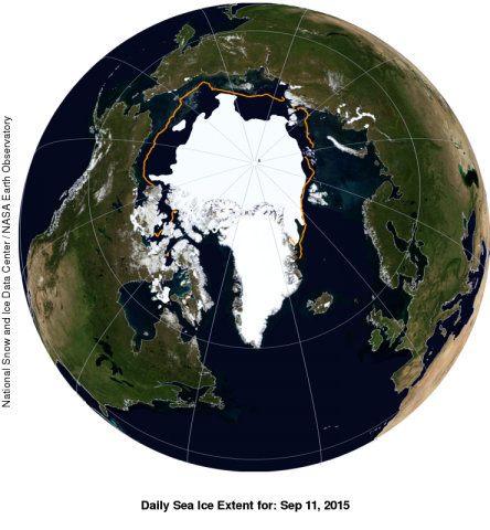
Arctic sea ice cover appears to have reached its minimum extent on September 11, 2015. Sea ice extent on that day was measured at 4.41 million square kilometers (1.70 million square miles).
Photo: NSIDC/NASA Earth Observatory
 It was the fourth lowest extent recorded since satellites began measuring sea ice in 1979, according to the National Snow and Ice Data Center (NSIDC), part of the Cooperative Institute for Research in Environmental Sciences at the University of Colorado Boulder. NSIDC scientists provide Arctic Sea Ice News & Analysis content, with partial support from NASA.
The extent ranked behind 2012 (lowest), 2007 (second lowest), and 2011 (third lowest). The nine lowest extents in the satellite era have all occurred in the last nine years.
The image shows a NASA Blue Marble view of the Arctic on September 11, 2015 when sea ice extent was at 4.41 million square kilometers (1.70 million square miles). The orange line shows the 1981 to 2010 average extent for that day. The black cross indicates the geographic North Pole.
The minimum ice extent reinforces the long-term downward trend in Arctic ice extent. Sea ice extent will now begin its seasonal increase through autumn and winter. In the Antarctic, sea ice extent is average, a substantial contrast with recent years when Antarctic winter extents reached record high levels.
The Arctic sea ice extent number is preliminary—changing winds could still push the ice extent lower. NSIDC will issue a formal announcement at the beginning of October with full analysis of the possible causes behind this year's ice conditions.